Artificial Intelligence and Geomarketing: find and lead a target client
5 February, 2020
Over the past 10 years, banks and other retail businesses have realized that big data is very important and useful. They are needed by any marketer: population and traffic, competitive environment, well-being of residents and the potential of locations. Given these factors, you can build a mega-efficient network of points of sale.Geomarketing is a marketing tool that uses many modern technologies. At the same time, the best results are achieved with the understanding of geopods at all levels — from the top management of the Bank to employees in the field. We have learned to build friendly relations between people and machines, in which geo-analysis becomes a common favorite child, it is supported and developed. We will tell about it on examples.
THE POTENTIAL LOCATIONS OF BANK BRANCHESBanks have always been attentive to the choice of location of branches, but expert assessments were sometimes inaccurate: only 50-60% of offices paid off on time.
Now, in the era of digital and huge amounts of information, there are opportunities to improve these indicators through a systematic approach and in-depth analysis of the components of Big Data. According to our statistics, up to 90% of offices opened with geomarketing tools pay off on time, and this figure is growing.
Typically, each such project begins with the creation of an expert layer, compiled from a list of clear rules for the success of the Bank branch. Usually, it is 15-20 rules that include population density, its financial position, public transport, targeted traffic customers, brands, competitors, and other options. We have collected more than 1500 metrics with spatial reference for more than 350 cities in Russia.
The list of rules is agreed and adjusted with the customer on the basis of its internal expertise, which takes into account the goals and capabilities of the Bank. Our experts apply the rules, calculate the values for each cell in the cities of presence specified by the customer. If the rule is met, the cell gets one point, if not — 0. When the whole area is estimated, it turns out "heat" map. And at the level of each location, you can easily and quickly understand what worked and what did not. Usually we do several iterations to achieve the greatest accuracy.
Our company has patented a number of developments that allow you to quickly calculate the entire territory of Russia to accommodate and improve the efficiency of Telecom sales points, retailers, offices of service companies, Bank branches, chain restaurants, industries and much more. One calculation of hundreds of millions of potential locations takes 42 seconds, so it almost does not matter for us what geography to work with. Each time the rules are adapted to the specifics of the customer's business. GEODATA allows us to distinguish the areas of responsibility between marketing, network, products and personnel at the level of each point, that is, to clearly identify what needs to be changed for the growth of business indicators of this point.
SPATIAL ANALYSIS ENHANCES MARKETING EFFICIENCY UP TO 40%Over the years, B&N Bank has had one of the widest regional networks in the financial market - about 400 branches throughout the country. The Marketing Logic team has implemented the Atlas business intelligence system in the Bank. It allowed to manage all marketing activities in the regions of presence, including the automated calculation of the results of attraction for each carrier. Plus, we have implemented the support of the technology “marketing seizure of the territory”, that is, the allocation of priority areas around the network of branches, where it is necessary to strengthen marketing investments due to external or internal factors.
"Artificial intelligence" in this case become a system that is a self-learning neural network. It analyzes the needs and characteristics of customers, business objectives, location of offices and the type of advertising media around the point of sale, and then offers the best set of the most effective channels of promotion, including outdoor advertising, Internet, radio and television. The interface allows you to monitor all marketing activities in real time and interact with Contracting agencies to adjust the media plan. In addition, the system independently accumulates data on the history of advertising placements and analyzes them by machine learning methods, which further increases the accuracy of each subsequent forecast.
As a result, geomarketing, Big Data and machine learning have increased the efficiency of customer acquisition, taking into account the individual characteristics of each region and individual office. Our joint project resulted in close cooperation, which allowed the Bank to reduce the cost of attracting new customers three times in some areas.
Location intelligence technology within the Atlas geographic information system is now also used in Rosbank to manage a network of more than 500 branches. The system aggregates data on all branches and divisions of the Bank, evaluates the potential and load, calculates the effectiveness of potential offices, based on data on the activity of customers, competing banks, population, traffic on the streets of the city and other statistical information. The Bank receives a "heat" map for each city of presence with an assessment of the potential location of the branch at the level of walking distance.
Today, our solution combines two approaches: machine learning and expert rules for choosing good locations, which allows us to combine the accumulated historical data and invaluable experience of experts — employees of the Bank.
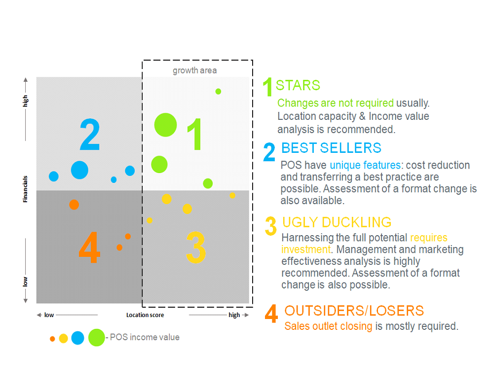
AN INTEGRATED APPROACH TO THE MANAGEMENT AND TRANSFORMATION OF THE NETWORK DETERMINES THE «STARS»An integrated approach to managing a network of offices allows for an in-depth analysis of the location. After that, our team of analysts, banking experts and management make a more detailed forecast and gives recommendations for further steps.
It should be said once again that excellent results are always joint work. We can provide our data marts, high-quality Analytics, implement machine learning, but only team project management and training models on actual customer data allows you to get accurate statistical information about the characteristics of the network and customer behavior: the actual coverage of sales points, the distances to which buyers travel for each of the products, penetration into the population, the competitive strength of the brand (the ability to intercept traffic from competitors and customers), objects that attract and repel customers, the ratio of local residents to "migrants" among potential customers, the importance of transport accessibility and critical distances to stops, etc.